The Flag of New York City

David Amiel, Vincent Ren, Raina Vettithanam, Amanda Chan

Flag of New York City

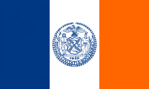
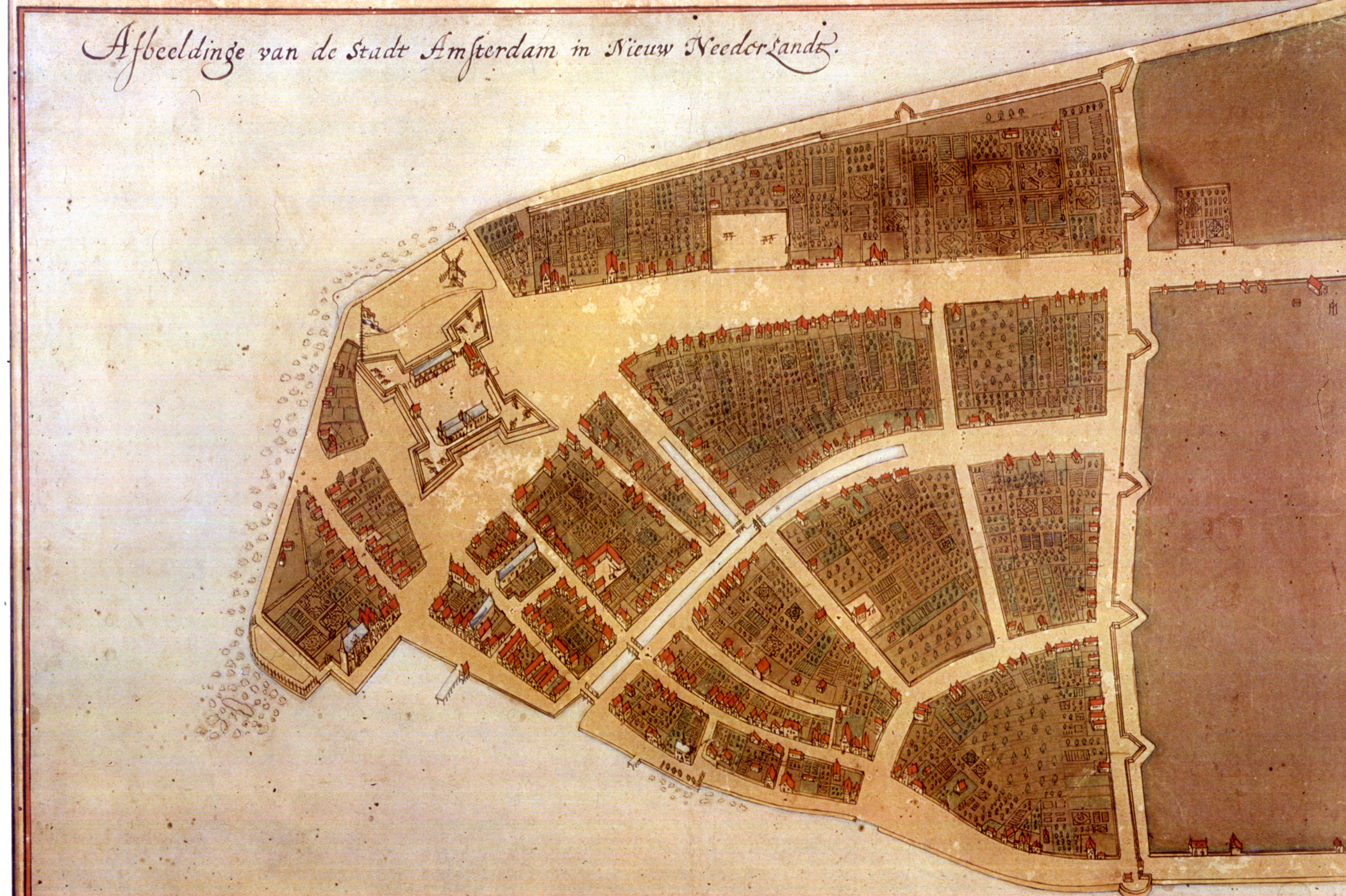
The NYC flag consists of the colors blue, white, and orange. The middle of the flag features the city’s seal, which possesses various symbols, each with their own symbolic representations. There is a native, a sailor with navigational tools, a windmill, flour barrels, beavers, and an eagle. At the bottom of the seal is a date of significance, 1625, which shows when the colony was founded, and at the border are the latin letters spelling out: “Seal of the City of New York.”

Our artifact can be found in the City of New York, and is on display outside all government and public buildings in the city. The flag was adopted by the city in December of 1977, although a variant of the flag exists at the mayoral office, which has five stars placed directly above the seal. The flag features many symbols which demonstrate the intimate connection between New York City and the Dutch. Looking closely at the seal, the beavers inside the coat of arms represent the Dutch East India Company, the first trade company to open trade to the city. Other Dutch influences can be seen inside the seal as well. For example, the windmill fans which divide the seal represent the prosperity of the flour-milling industry, whose prosperity directly affected the economic success of New York City, at the time, the New Netherlands. Furthermore, the figure on the left of the seal is a colonial seaman, which also points to the Dutch’s founding of New Amsterdam; to his right is a native, which represents the original indigenous population.

This intertwining of histories resonates with many people, considering the population of the city. The flag, which is a symbol of the city, and in the past, a source of great pride for its inhabitants, is a reminder of the city, and the country’s, connection to the Dutch. The year 1625, which is printed in the city’s seal, is the year in which New Amsterdam was founded by the Dutch. Although hundreds of years have gone by, the flag is still a present-day reminder of the city’s roots.

We chose this artifact because of its abundance of connections to our inter-woven histories with the colonial Dutch. New York City is close to home for many Rutgers students, and its influence extends well beyond the city’s borders. In investigating the influence that the Dutch had on New York City, the cultural center of our country, we were able to see not only that much of our colonial history and prosperity is due to the Dutch – specifically the Dutch East India Trading Company – but to appreciate the deep connections that exist between our two societies.

External Sources:

NYC Green Book Highlights - City Seal and Flag
The Official New York City Flag

Castello Plan

icon-car.png
Castello Plan

loading map - please wait...

Castello Plan 43.819447, 11.228183

By: Lauren Weissman, Alec Meacham, Nareena Imam, Huiwen Guan

1660 Map of New Amsterdam (New York City):


Interactive Map

What is It?

Our artifact is a 1660 map called The Castello Plan. While the original is lost, it was last seen in 1916 in Villa di Castello when it was redrawn. The map shows Manhattan in the 17th century, a time when Wall Street was literally a wall built to section off the Dutch from the natives. While there are several street names that sound familiar to us today, such as Broadway, Wall Street, and Pearl Street, there are also a series of canals that are unfamiliar to us today. Reminiscent of life back in the Netherlands, the Dutch built these canals for easy transportation of goods in and out of the city. And even though the original map is lost, there is a popular 20th century copy currently on display in the New York Public Library.

1660 vs Today:

Essay:

Our artifact is the Castello Plan, a 1660 redraft of an original Dutch map of New Amsterdam. It is one of the earliest known maps of Manhattan created by Jacques Cortelyou (ca. 1625 – 1693), a surveyor in the New Amsterdam. While the original survey has since been lost, a copy was created in 1665 by an anonymous individual. Presently, it is located in Italy, in a collection of Dutch maps that belonged to Cosimo de’ Medici III, who acquired it during a trip to Holland in 1669 from the cartographer Johannes Blaeu, who put it into an atlas.

Created only four years before the city would be renamed New York, the Castello Plan represents the progress towards colonization which the Dutch made between the years 1609, when Henry Hudson first discovered the region, and 1660. The infrastructure of the rising city is shown as seen in the layout of the streets but also included are elements of Dutch design and architecture as seen in the buildings and the inclusion of numerous gardens within the city walls, showing evidence of Dutch traces in horticulture in New York.

We chose to feature this artifact because of our connection with New York City, due to its proximity to New Jersey. It is a city we have been exposed to for years, and may have even walked past or seen things outlined in the Castello Plan. Previously, we did not consider the impact the Dutch had on New York because of the amount of time that has elapsed since they were here. However, this artifact shows us that we should be more aware of the Dutch presence, because it is deeply embedded in the history of the city.

As one of the earliest known maps of New York City, the Castello Plan is a symbol of how entwined the histories of America and the Dutch are. There is evidence that places relevant to residents even now have Dutch influences, such as buildings that still line the streets drawn carefully in the map. Documents along with the Castello Plan record the owners of buildings and what they did, showing that even back then New Amsterdam already had the diverse culture characteristic of modern day New York City.

Works Cited:

http://www.nyc99.org/1600/castillo.html

http://digitalcommons.buffalostate.edu/cgi/viewcontent.cgi?article=1080&context=neha

http://www.nyc.gov/html/lpc/downloads/pdf/reports/STONE_STREET_HISTORIC_DISTRICT.pdf

http://www.wired.com/2013/10/new-york-city-maps/

Return to home page.