A Silver Seal for Marbletown, New York

By Neil Gandhi, Fangling He, and Jarisha Olanday from Section 2


DP242556

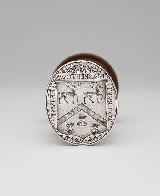
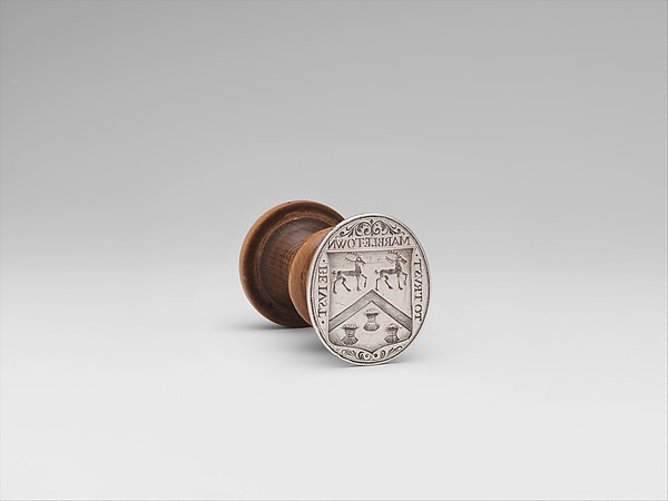
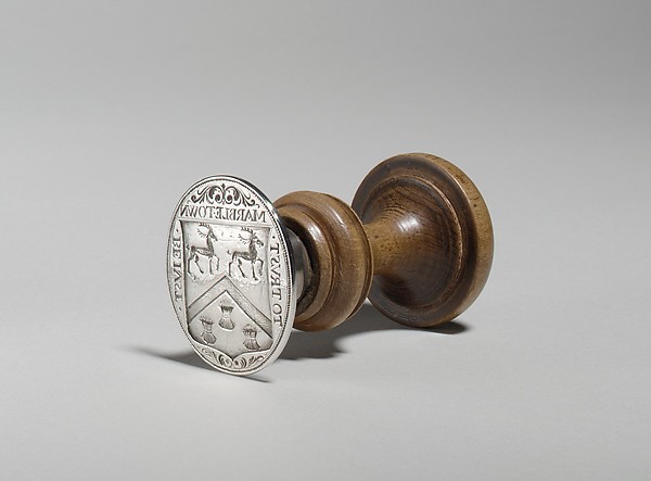
This seal was created by Dutch silversmith Jacob Boelen in 1704 as an official town seal for Marbletown, New York, used to stamp official documents. The head of the seal is made of official silver that is placed on top of a wooden handle. Engraved on the seal is the town’s coat of arms. The upper region of the coat of arms above the chevron, are two deer that symbolize the town’s hilly uplands and mountainous surroundings that served as hunting areas. Below the chevron are three sheaves of wheat that symbolize the surrounding fertile lowland that suited the cultivation of grains. Above the shield is a reversed engraving of “MARBLETOWN”. On the sides of the shield is a reversed engraving of the town’s motto “BE IVST(left)/ TO TRVST(right)”, or “Be Just To Trust”.

       DP242566DP105041

The seal is currently located in The Metropolitan Museum of Art, specifically The Met Fifth Avenue. The seal was previously located in Kingston, New York and owned by Alphonso T. Clearwater since 1925. In cooperation with Marbletown, the seal was bequest by Clearwater to the Met in 1933.

icon-car.png
The Metropolitan Museum of Art -The Met Fifth Avenue

loading map - please wait...

The Metropolitan Museum of Art -The Met Fifth Avenue 40.779238, -73.963004
The Story of the Seal

The seal tells us about two things: the story of its creator and the story of why it was created.

Jacob Boelen, the creator of the seal, is a notable Dutch silversmith who was born in Amsterdam, Netherlands in 1645. He worked as a silversmith in New York City, NY from 1660 to his death. Many of his surviving works, like this seal, is exhibited today in the Metropolitan Museum of Art, Yale University, and the Museum of the City of New York. His beautiful silver work range from spoons, various cups, teacups, tankards, and,  of course, this seal.

icon-car.png
Marbletown, New York

loading map - please wait...

Marbletown, New York 41.884899, -74.113083


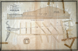
The seal was created in 1704, a year after Marbletown received its patent on June 25th, 1703. A group of Americans and Dutchmen applied for the patent and was granted by Col. Henry Beekman, Capt. Thomas Garton and Capt. Charles Brodhead in trust for the inhabitants.  After the city of Kingston (the first capital of NY, northeast of Marbletown) was burned by the British during the American Revolution in 1777, Marbletown briefly served as the states capital. The Town of Marbletown was officially formed in 1844, after regions of the land were used to form the Town of Olive(1823) and the Town of Rosendale(1844). Marbletown was heavily influenced by the Dutch which is evident through its architectural heritage and its districts (like Kripplebush – that is definitely Dutch!).

What does it tell us today?

The seal is still a great symbol of Marbletown, New York today. Much of the rural community is underdeveloped, leaving a scenic landscape of mountains and fertile land, just as the seal’s coat of arms still depicts. Marbletown retains its history and architectural heritage through a sprinkling of many historical zones across the region. Within Marbletown are four locations that are registered in the National Register of Historic Places: Bevier Stone House, Rest Plaus Historic District, Cornelius Wynkoop Stone House, and Kripplebush.

The surviving architecture in these districts, many of it made of stone, embody Dutch vernacular architecture of the 17th and 18th century. Additionally, some districts and places of Marbletown are agriculturally centered; its 19th century and early 20th century framed community institutions, rural domestic, manufacturing and commercial buildings embody the town’s expansive involvement in agricultural enterprises. Its build environment genuinely preserves this rural neighborhood’s historic growth and accompanying changes in land ownership and new construction through a range of domestic, commercial, and institutional structures. In this fashion, through its distinct inscriptions and motto, the seal remains symbolic to Marbletown’s historic identity.

We decided to pick this object because it represents a town that was originally founded by the Dutch. It is important to remember many towns in the Northeast were founded by Dutch settlers way before the English ever got there and that the Dutch play a huge part in our history. This seal is a very simple object that signifies a lot and has a lot of symbolic meaning behind it.  Usually, when we think about any kind of seal, we do not stop and think about all of the meaning and history behind it. This artifact that made us realize how much history and the amount of significance such a small and simple artifact can have.


Resources:


Theodore Frelinghuysen – The Dutch Abraham Lincoln

The First Reformed Church at 9 Bayard Street in New Brunswick not only serves as one of the most historic buildings in New Brunswick, but as the final resting place for Theodore Frelinghuysen. The only problemis that the whereabouts of the grave of Mr. Frelinghuysen, seventh President of Rutgers University (then Rutgers College) & former US Senator from NJ, is unknown as it has been lost to the weathering of the cemetery and the neglect from the caretakers. However, the lack of a physical object does not mean that Mr. Frelinghuysen’s body is not buried at the Dutch church’s resting site, nor does it take away from the accomplishments of this man that are owed to the Dutch dynasty he was a central figure of.

IMG_3382

(Not pictured: Theodore Frelinghuysen’s headstone)

icon-car.png
9 Bayard St, New Brunswick, NJ, United States

loading map - please wait...

9 Bayard St, New Brunswick, NJ, United States 40.495057, -74.442349

Theodore J. Frelinguysen, Theodore’s great-grandfather, served as the minister of the First Reformed Church in New Brunswick and was central to the First Great Awakening, and with that, the spread of Dutch-influenced Christianity. Additionally, as part of the Church leadership position, TJF was very involved in the founding of Queen’s College and  Theodore’s father served in the Revolution, and many of his relatives were influential in local politics and the goings of daily life. In New Brunswick, the Frelinghuysens were the Kennedys. With this inevitability on his shoulders, Theodore attended the College of New Jersey (now Princeton) and practiced law with his brother and Richard Stockton, whose name recognition rings just as true today as it did then.

Frelinghuysen flourished in the political sphere in which he served as US Senator from New Jersey and had many of his votes and political actions influenced by his religion and Dutch roots. He was even the vice-presidential candidate under Henry Clay in the 1844 Presidential Election. Frelinghuysen was an abolitionist when it was unpopular to do so, and his path eerily followed the beginnings of Abraham Lincoln’s: “a lawyer, a politician, a Whig-turned-Republican… had a strong religious commitment and personally found slavery immoral… sought to preserve the Union and hesitated to follow the abolitionist line of denunciation of the South.” (Eells 68). Unfortunately, Theodore didn’t try again for higher office, but he did return to his New Brunswick roots to serve as the seventh President of Rutgers after his stint at New York University.

The shame about Frelinghuysen’s missing grave is that it could have been one of the few monuments to the man and his career. Buildings around Rutgers bear his family’s name, such as the dormitory or the street, but that is not directly Theodore’s honor to be had. In fact, it seems much of what Theodore stood for was something that should have been remembered, or at least recognized to be significant during his time, which is one of the main reasons we wished to recognize his achievements. Accounts of Frelinghuysen’s speeches on the floor of Congress remember him as a passionate, reasoned man who represented his constituents well, so he deserves, if not a grave, a marker of his significance to the nation and our community here in New Brunswick.

Sean Giblin, Laura Friedman, Evan Pié (Section 10)

Works Cited
Eells, Robert. Forgotten Saint: The Life of Theodore Frelinghuysen: A Case Study of Christian Leadership. Lanham, MD: U of America, 1987. Print.
“FRELINGHUYSEN, Theodore – Biographical Information.” FRELINGHUYSEN, Theodore – Biographical Information. N.p., n.d. Web.
“Theodore Frelinghuysen (1787 – 1862) – Find A Grave Memorial.” Theodore Frelinghuysen (1787 – 1862) – Find A Grave Memorial. N.p., n.d. Web.

Return to home page.

America and the Netherlands: separated by an ocean but connected by a flag

By: Varun Uchil, Rini Bhattacharyya, Rohin Nair, and Yehonadav Feygin

Section: 07

American flag flying in the wind

The American flag, which originally had 13 stars – arranged in a circle – and 13 stripes in order to reflect the amount of colonies present at the time, is a banner that is commonly flown throughout the country and its territories. It has 50 stars to represent the 50 states in America, but maintains the 13 stripes to represent the original 13 colonies. The stars are white, and arranged in a square pattern in front of a square blue background, and the stripes alternate between red and white.


american-flag-2
The National Animal of America, the Bald Eagle, superimposed on the National Flag
icon-car.png
alexander library

loading map - please wait...

alexander library 40.505055, -74.452415
146043468264170
This picture indicates the American flag displayed in front of Alexander Library, which also marked on the preceding map.

Essay   

The American flag is a common staple of most neighborhoods in the United States, with, most neighborhoods containing at least a handful of flags and with some neighborhoods where a front yard WITHOUT a flag would be considered amiss. The American flag can be found in various different places such as office building, educational establishments, and even homes. It is a symbol of this country’s freedom from British reign and is representative of America’s values. Betsy Ross was chosen by George Washington to create the first American flag which had thirteen stars to represent the thirteen colonies. As colonies, and later states, were added to the nation, the flag was correspondingly altered to reflect this, with the latest edit coming in the late 1950’s with the addition of Alaska and Hawaii as states. Common folklore had always indicated that the first foreign salute of a flag came in 1778, in the Quiberon Bay in France. However, more contemporary research on the subject indicates that the first foreign salute of the original Stars and Stripes actually came 2 years prior, and was carried out on the U.S.S. Andrew Doria and conducted by Dutch Captain Johannes de Graaf. The American Flag has no direct connection to Rutgers University but if one really thinks about the American Flag, many of the ideals it represents are a direct the origin of the ideals of Rutgers. The constitution, which is a directly represented by the American Flag, states that everyone should have an equal opportunity to chase the American dream, and to have the freedom to choose what and how he or she wants to accomplish regardless of race, gender or religion. Rutgers directly emphasizes this ideal, as it is ranked the second most diverse AAU public flagship institution in the “U.S. News & World Report” rankings. The American flag may seem like a strange artifact to choose to draw a connection to the Netherlands. However, in context of the theme of “Shared Values” among the two nations, the connection appears to be given a new validity. The reason that we chose the American flag as our artifact, as stated previously, is that the Dutch were the first foreign country to recognize the United States as a sovereign nation from the crown. However, the underlying connection between the Dutch and the United States actually goes deeper than this historical anecdote. The Netherlands and the United States are both free nations that are at the forefront of the new age, a scenario that would not be possible without the paramount value that liberty takes in both societies. Today, the American flag is a symbol of patriotism. People revere the American Flag and most households or institutions contain one or more flags. The Flag is a symbol of what it is to be American. It has 50 stars, encompassing all fifty states, and thirteen stripes to pay homage to the original thirteen states of the union. The Red Blue and White are iconic in American culture. Many products in shops use these colors in order to appeal to Americans. This prompts an interesting question. Why does the flag appeal to people? The Flag is the most direct symbol of American independence and power. The Flag asserts American authority, as evidenced by the planting of the flag at Iwo Jima. It also invokes a sense of pride in the country. Americans believe the flag to represent the country as a whole, which is why they face it while reciting the pledge of Allegiance. Every person in America, regardless of their differences accepts the flag as a symbol of unity. The Flag is so respected that desecration of the flag is highly frowned upon. Perhaps, the best way to describe the American flag would be to use the word sacred. “O say does that Star Spangled/Banner yet wave/O’er the land of the free/and the home of the brave” – Francis Scott Key, 1814. Though a statement made almost half a century after the original American flag was made, there is perhaps no more relevant line to the ideals embodied by the emblem of our nation. The line, which is also a famous part of the national anthem, indicates that the speaker, Mr. Scott Key, is imploring us to forever fly the flag over our prosperous and free nation. In 1909, The New York Times actually published a fascinating piece on the first recorded salute to the American flag. It explains that “The first recorded salute by a foreign officer to the flag of the Continental Congress and the United States of America was at the island of St. Eustatius on November 16, 1776, by the Dutch governor, de Graeff, after his reading the Declaration of Independence.” The article also goes on to explain De Graaff’s forward-thinking acceptance of the United States America by not only showing his support to the American government against the British crown, but also by opening the Dutch harbor at St. Eustatius to freely trade with the Americans.

Bibliography

  • http://query.nytimes.com/mem/archive-free/pdf?res=9E04E4D9103EE733A25752C1A9649C946797D6CF
  • http://www.history.com/topics/american-revolution/betsy-ross
  • http://www.history.com/this-day-in-history/key-pens-star-spangled-banner

Return to home page.

Cornelius Low House

icon-car.png
Cornelius Low House

loading map - please wait...

Cornelius Low House 40.511957, -74.465198

Joseph Acoury, Sneh Shah, Reshni Mahtani, Aaron Wong

Our artifact is the Cornelius Low House located at 1225 River Rd, Piscataway Township, NJ 0885. It was built in 1741 and the land for the house was purchased from William Williamson. The owner of the house,  Low’s family is originally from Holland and is therefore Dutch. His grandfather eventually left Holland and migrated to the Americas. Cornelius then moved to New York and established himself as a merchant. Cornelius picked the Raritan location to build his house because it overlooked the pier and his warehouse, which he was then able to keep a watch on. The house was built on grounds that are now part of Rutgers University. Our visit to the house sparked an interest in it. Hearing about its dramatic history and its origins exciting all of the members of our group, so making this choice was fairly easy.

Cornelius_Low_House_(2008)

The house’s transformation to a museum is very interesting. In 1979, Middlesex County, New Jersey bought the house and grounds. Under the guidance and administration of the Middlesex County Cultural and Heritage Commission. The County acquired the Low House to use as a local heritage museum for discussing the history of New Jersey and its context within that of national events. As the home of the Middlesex County Museum, the Low House was established to provide exceptional, educational experiences through the presentation of original research relating significant people, historic places, events and attitudes to the State of New Jersey. At the moment, the Low House is an exhibit of the history of New Jersey diners.

Return to home page.

City Tavern

Dylan Vail

Daniel Hernandez

Section 8


City Tavern was one of the first taverns built in New York, and it became the first City Hall/ State House ever built in Manhattan.  A meeting place for all citizens and meant to accommodate meetings of business and order, it was important to the city and for what the city would eventually become.  It was located on Pearl Street which had been where the city met the river before the expansion of New York, and where fishermen and hunters frequented.

The above image is outside of 85 Broad, in NYC, and the yellow bricks outline the foundation of where City Tavern used to be.

icon-car.png
City Tavern

loading map - please wait...

City Tavern 40.703804, -74.011217

Essay:

My object was located on the corner of Coenties Slip and Pearl  Street back in the colony of New Amsterdam, and is now the near the street in front of 85 Broad, and Pearl. The governing groups realized they had to be in touch with their citizens and so Director-General William Kieft had a stone tavern built in 1642.  In 1653 it was officially commissioned by Petrus Stuyvesant and named the Stadt Huys (State House), but was known less formally as City Tavern.  It was used as a gathering ground for all people of the city and meetings were often held there.

The first order of business after signing the municipal charter was to declare:

“herewith [to] inform everybody that they shall hold their regular meetings in the house hitherto called the City Tavern, henceforth the City Hall, on Monday mornings from 9 o’clock, to hear there all questions of difference between litigants and decide them the best they can”

The tavern was only about a two-minute walk from the fort, and so the governors often used it as a place to entertain or send their guests when they were hosting.  It was a place for refugees arriving to the city, soldiers stationed there, citizens talking at night, less desirable individuals, as well as the elite who often frequented it.  It was a place where problems were solved and issues raised, where organizers and activists rallied, and where even the Board of Nine was said to have used it for their purposes.  After issues with the British and other historical events, the title of State House was given to the Lovelace Tavern next door in 1697.  But both would eventually be destroyed, with most attributing this to a fire in 1706.  During construction of 85 Broad in Manhattan, the foundations of Lovelace Tavern were found and so the spot of City Tavern was also discovered.  This object was integral to the colony of New Amsterdam and what it would eventually become in the great city of New York.  The artifact tells how the Dutch were organized and prepared and worked to integrate their people, as well as how they met to face problems and make decisions that we see as progressive today.  It still speaks today as its place is outlined in the streets to signify its historical importance in a city that is constantly developing and progressing.  And it was chosen because of the interest brought to it by a source website that was stumbled upon, and after seeing its historical importance and its lesser known status, it had to be given some sort of attention.

Bibliography:

http://www.anthropologyinpractice.com/2009/11/finding-traces-of-new-york-citys-dutch.html

Manhattan’s first taverns: Wooden Horse and City Tavern

http://www.billsbrownstone.com/DutchDays/CityTavern.asp

http://www.coins.nd.edu/ColCoin/ColCoinIntros/Netherlands.html

Return to home page.

The Raritan River

Authors: Austin Hong, Noah Hoffman, Kyle Kopcho, Andy Sivas

The Raritan River 

Found online by Austin Hong via Google Images

The Raritan River is a beautiful body of water that empties into the Raritan Bay. It flows for about 16 miles before it hits its estuary which extends the river an additional 14 miles. There is a total of four bridges that span the Raritan. They are the New Jersey Transit Railroad Bridge, Victory Bridge, Edison Bridge, and Driscoll Bridge.

Map of the River’s Location

Found online by Kyle Kopcho via Google Images

       The Raritan Headwaters region is located in north-central New Jersey and is defined by the area of land that drains into the North and South Branches of the Raritan River. The region contains the headwaters of the Raritan, the river which drains to the Raritan Bay and Atlantic Ocean. The drainage basin of the Raritan River covers approximately 1,100 square miles, making it the largest river basin located entirely within the State of New Jersey.

     A significant part of New Jersey’s rich cultural history, the Raritan River has served as a transportation and trade route since pre-colonial times. The Naraticongs, a branch of the Lenape and part of the Iroquois Nation, were the first known settlers of the Raritan Valley. The Dutch and English arrived in 1683 and also made use of the River for its fertile soil and transportation opportunities. The Raritan was crossed by troops during the American Revolution, and a battle was fought close by in 1777. During the Industrial Revolution, the River became home to mills and other factories.

      The first people to settle the Raritan Valley were the Naraticongs, a peace-loving branch of the Lenape who were part of the Iroquois Nation. Numbering about 1,200 the Naraticongs lived mostly along the north side of the river. They roamed the forest to hunt, fished in the river, and planted corn in the fertile valley. In 1683, when the Dutch and English arrived, the Naraticongs met them with friendly advances and a ready sale of land. The Dutch shortened and altered the name of the Naraticongs and named the area Raritan, or “forked river” Other versions of history state that Raritan translate to “where the stream overflows”. The Dutch, English, and French Huguenots were drawn to the area for the same reasons the Lenape Found appealing-the rich, fertile soil and the navigable river. The Dutch also realized they could establish their own church, the Dutch Reformed Church, and live in freedom. These opportunities played a major role in the establishment of the town of Raritan. Raritan became a trading center for neighboring farmers.

      The Raritan River is located within central New Jersey in the United States. The Dutch arrived at the Raritan River in 1683, and started a colony in New Brunswick upon recognizing the unused potential stored in the roots of this area. The land around this body of water was an ideal location for starting a colony. The fertile soil made it a good area for settlement and the river would serve as an excellent means of transportation that could be used for trade. Furthermore, the Raritan River was an important route used for slave trade, and slaves were important resources that were utilized in the establishment of Queens College.


       The Raritan river is one of the largest and most influential landmarks in Rutgers history, as well as the history of New Brunswick. The early colonies that led to the establishment of New Brunswick,and later Rutgers, would not have been able to survive without the aid of the Raritan River. The Raritan allowed easy access for resources and new settlers to come to the New Brunswick area. The Dutch were among the first to use this natural resource and take advantage of New Brunswick’s location, and their effect is still felt to this day. Also, as students at Rutgers University, the river is a part of our community and we want to learn more about this historical landmark.

       From a current geological perspective, the Raritan River’s role today in the New Jersey ecosystem is that of a major river, which contributes to the draining of the central, mountainous areas of New jersey into the Atlantic Ocean. Furthermore, this river’s history is celebrated in the Rutgers alma mater for it’s relevance to the establishment of Rutgers and the Dutch involvement with it. The river today is an important geological landmark, but can also be used for recreational purposes. The crew team here at Rutgers rows almost everyday on the water, and oftentimes, when in season, hosts regattas with schools from around the country.

       The Raritan river, as previously stated, was a very important trading route utilized by Dutch and English settlers. Initially, Native-American tribes, like the Iroquois, inhabitedword the banks of the raritan, which is where Rutgers now stands. Essentially, the soil was very fertile and the surrounding ecosystem was conducive to establishing a vibrant community, which included a school. Essentially, Rutgers was founded on the banks of the Old Raritan because the atmosphere was suitable for the construction and maintenance of one of the first schools ever established in the New World. The English and Dutch settlers clearly saw it the same way.

Bibliography

  • “Natural History.” Raritan Headwaters Association. Web. 11 Apr. 2016. https://www.raritanheadwaters.org/home/learn/natural-history-of-raritan-headwaters-region/
  • “The History of Raritan.” The Official Website of The Borough of Raritan, NJ ::::. Web. 11 Apr. 2016. http://www.raritanboro.org/History/
  • “History of the Raritan River.” Raritanrutgersedu. Web. 11 Apr. 2016. http://raritan.rutgers.edu/raritan-basin/history-of-the-raritan-river/

Return to home page.


Abraham Staats House

Moksh Gudala and Sukeerthi Bitra

The Abraham Staats House is located on the banks of the Raritan River on 17 von Steuben Lane, in South Bound Brook, New Jersey, which is about 5 miles up the river from Rutgers College Avenue campus. Abraham Staats, who was one of the original dutch settlers in a land then known as New Netherlands, his wife Margaret DuBois, and his six children lived in this house in the mid to late 18th century. During the Revolutionary war, Staats was a known patriot and rebel against the British. Staats was even considered an “arch traitor” by the British, as “local legend suggests that Staats was involved in a spy network” (Staats History).

General Baron von Steuben, who was the inspector general of the army, was eventually quartered at the Staats’ house during the war, and during his extended stay, many famous figures from the Revolutionary War, such as George Washington, visited the Staats’ house to meet with General von Steuben. General von Steuben even held a ceremony for the French Minister Girard during his stay, which included a reception where eight regiments of soldiers came to honor Washington and the army. We chose the Abraham Staats House in particular because it shows the importance of Dutch heritage and how it can still hold value in a place that is close to our home. This house is one of the finest standing buildings left from the Dutch settlement that holds a rich history. The Abraham Staats House is a reminder to Rutgers students of the historical value of the area around Rutgers both in the existence of Dutch settlements and the role the people of this area played in the Revolutionary War.

Home to a New World Dutch family for nearly 200 years, the Abraham Staats House has been enlarged many times and now includes a Federal/Greek Revival two-story addition. The central part of the house is the oldest and the west and east wing were added later on in the 18th and 19th century. Some notable features of the house include an old kitchen with a large fireplace and a Dutch-style staircase. Standing as one of the greatest remaining buildings from the Dutch settlement of the Raritan Valley, this house has been added onto the New Jersey Register of Historic Places.

icon-car.png
Abraham Staats House

loading map - please wait...

Abraham Staats House 40.551541, -74.520681


Bibliography:

http://www.staatshouse.org/

http://gardenstatelegacy.com/files/The_Abraham_Staats_House_Ormosi_GSL1.pdf

Return to home page.

Carrots: Selectively Bred From the Land of Orange

By William Radin, Rashi Rattan, Ethan Chiang (Section 2)

Carrots

Jeremy Keith via Flickr CC by 2.0

The carrot is a (usually) orange vegetable that is a staple in many cuisines around the world. They are grown in the ground and cultivated for their taproots, the well known orange vegetable. The leaves on the top of the carrot are not usually eaten, and are discarded when carrots are eaten.

Here is only one example of the many farms that grow carrots here in New Jersey:

icon-car.png
Carrot Farm

loading map - please wait...

Carrot Farm 39.580075, -74.934286

Carrots today are one of the main vegetables eaten in American cuisine. Many salads, soups, as well as healthy snacks include these orange vegetables. The United States is the fourth largest producer of carrots in the world. Many places all over the nation grow carrots, including here in New Jersey. However, a closer look at the history of carrots shows a surprising Dutch influence.

The most surprising fact to many people is that carrots actually come in all different colors, from purple to yellow to red to white! While the carrot most likely originated in Central Asia, it made its way both West and East. While Eastern carrots were purple, slowly the yellow rooted carrot made its way to Europe by the 13th century.

The Dutch were the ones to selectively breed the orange carrot. Modern genetic studies show that they took the yellow rooted carrot and over generations, created an orange carrot that was healthier and less bitter. Despite common folklore, the carrot was not orange to honor the Dutch House of Orange, but rather was made the official Dutch vegetable afterwards.

With the advantages of the orange carrot over the other hues of carrots, the orange carrot the sole type of carrot planted in Europe. As part of the Colombian Exchange, the carrot made its way to the New World aboard Spanish, English, and Dutch ships. Today, the importance of the carrot as a crop is unprecedented, and it continues to be a healthy snack for all.

We chose this topic because very few people think about the history of their food, and we were surprised to see that such a common crop actually had Dutch roots. The domestication of the carrot is only one of the accomplishments of the Dutch that go unnoticed, yet it is a case of agricultural advancement for the time period, once again showing that the Dutch managed to become a world power in such a short time!

Works Cited:

http://www.carrotmuseum.co.uk/

http://www.agrilicious.org/Summer-Wind-Farms

https://en.wikipedia.org/wiki/Carrot

Voorhees Mall

Jenish Patel, Ravi Desai, Kishan Patel

Section 6

———————————–

VOORHEES MALL


Jenish Patel via Google Images CC BY-NC-ND 2.0

Voorhees Mall is located at the heart of the College Avenue campus at Rutgers University in New Brunswick. The nature like scenery along with the old traditional style lecture halls gives this strip of land a campus atmosphere. On one side sits the new honors college dorms buildings, and on the other sit a few buildings built a long time ago such as the church. During the weekdays of the semesters, students are constantly walking through the Voorhees Mall, taking in the beauty of nature and the sights of the buildings and even the statue of William the silent.

icon-car.png
Voorheen Mall, Ritgers University

loading map - please wait...

Voorheen Mall, Ritgers University 40.500095, -74.447340

Essay:

     For our project we decided to trace Voorhees Mall on the College Ave Campus of Rutgers University. Voorhees Mall is located near downtown New Brunswick, New Jersey. The mall was originally formed in 1903 when a city street by the name of Bleeker Place was closed. After several donations to Rutgers, including what is now known as Voorhees Hall, the grassy mall was named after Ralph and Elizabeth Rodman Voorhees. The sizable donations by the Voorhees show the virtues and selflessness of the Dutch. Originally a $60,000 donation from Mr & Mrs. Voorhees helped build the Ralph Voorhees library which would later become Voorhees Hall. Mrs. Voorhees continued her charitable work by donating an additional $150,000 for enlargements and new equipment in 1907. It is interesting to note that the name “Voorhees” is tied back to a one Steven Coerte. Steven Coerte, his wife, and eight children resided on a farm located near the village of Hees in the Province of Drenthe in north-east Holland around 1660. Under later British rule, he adopted the surname: “Van (before) Voor (village) Hees.” Everyone with the name Voorhees is tied back to him, including Ralph and Elizabeth Rodman Voorhees.

     However, Voorhees Mall is not only connected to Rutgers by location. The Mall was also the site of the annual commencement for Rutgers College. More recently, the Mall was used during Rutgers Day for new and current students to enjoy. We decided on Voorhees Mall because not only are many of our classes there but also because it is where we first fully experienced our University on Rutgers Day. It is amazing to see how an area we walk by everyday can be filled with so much history. Voorhees Mall is also home to some historic sites such as the statue of William the Silent. Voorhees Mall not only provides aesthetically pleasing lush fields and statues but also represents some of our rich Dutch history.

Bibliography:

  1. “Voorhees Mall, Site of Commencement, Rich in Rutgers History.” Voorhees Mall, Site of Commencement, Rich in Rutgers History. N.p., n.d. Web. 10 Apr. 2016.
  2. “Then and Now: A Photographic Study of Rutgers’ College Avenue Campus, Part 2.” Muckgers. N.p., 30 Apr. 2014. Web. 10 Apr. 2016.
  3. “Paths to Historic Rutgers: A Self-Guided Tour.” Rutgers University Libraries: Special Collections and University Archives:. N.p., n.d. Web. 10 Apr. 2016.

Return to home page.

New Brunswick Mines

Steven Leichner, Makenzie Bayless, Isha Khosla, Connor Grant

Section 2

mapimage

The copper mine is currently under, what is today, the Voorhees Mall on the College Avenue Campus. It runs parallel to Hamilton Street and Mine Street. It passes through Robinson Street, Hartwell Street, Guilden Street, Easton Ave, Union Street, and College Avenue. The mine is about 60 feet under the ground and allegedly runs hundreds of feet under the Raritan River. The Dutch created many mines in New Jersey during the 1600s. The New Brunswick mines were first discovered fruitful in the 1750s when the owner of the land, Philip French discovered heavy chunks of copper. Philip French, the reason we have a French Street, had to soon allow a copper mining company to lease his farmland. The mine is no longer used.

In 1751, a New Jersey mining company led by Elias Boudinot contracted a century-long lease on French’s farm. The company subsequently dug a mine approximately 300 feet from the Raritan River and uncovered heaps of copper. The mines that are now replaced by Rutgers University’s property tells the story of the Dutch that arrived in America and attempted to make a profitable living through the mining industry. Stories of the Dutch can be seen through investigations of Ford Hall, which has a tunnel that used to be a mine shaft. The investigation discovered locked up rooms, crawl spaces, and stairwells that indicated previous activities in the underground tunnel. The mine shafts created by the Dutch are also involved in other parts of American history. The mine that once ran down Mine Street is said to have been a means of escape for slaves and a passage for smuggling alcohol during Prohibition.

The fact that there are little-known, yet extensive, mines under the College Avenue campus illuminates that New Brunswick has a deep, rich history that is not very well-known to the Rutgers community. A portion of this mine shaft, as previously mentioned, is even present in Ford Hall. It’s a shame that we tend to be so present-oriented, and that there is a long history of this area that is often neglected. We picked the mine shaft largely because of its relative anonymity. When Makenzie first mentioned that there were abandoned mines right underneath College Avenue, I was very surprised and wondered how many people even knew about the mines. For this reason, we thought we should do our project on the mines; to give people this same surprise, and broaden their knowledge of the history of New Brunswick.

The underground mine shafts located below certain areas on the College Avenue campus are a simple microcosm of the extensive history surrounding Rutgers University. Much of this history is not recognized by the students and faculty of Rutgers, alongside the other inhabitants of the city of New Brunswick. I believe the unknown presence of these shafts, especially those used as escape routes for slaves, a passage for arms, and the transportation of alcohol during Prohibition, are something that would fascinate others if they knew. To realize there is something out of view that is so complex and historically valuable right below the streets we walk on is captivating, but also unfortunate that its presence is generally not acknowledged. It teaches us that no matter where we are, there is a history behind our environment that we should learn to embrace because modern society tends to ignore these facts. Who would have known the reason why MIne Street has its name? Ultimately, we should look beyond what is present in our field and sight to gain a new appreciation for the world around us and teach others to do the same.

icon-car.png
ford hall

loading map - please wait...

ford hall 40.500499, -74.448738


BIBLIOGRAPHY:

http://www.njgeology.org/enviroed/minemaps.htm

http://newbrunswicktoday.com/article/flooding-brought-end-mining-operation

http://www.state.nj.us/dep/njgs/enviroed/oldpubs/SG-Annual-Report-1906.pdf

http://www.state.nj.us/dep/njgs/enviroed/oldpubs/bulletin57.pdf

Return to home page.